-
-
Platform Overview Platform Overview
High-precision data and advanced tooling in one place
-
Maps & Data Maps & Data
Build high-quality maps using fresh location data
Maps & Data-
Map Data Map Data
Create fresh, accurate maps and layer global information
-
Dynamic Map Content Dynamic Map Content
Explore industry-leading map content
-
Maps for ADAS & HAD Maps for ADAS & HAD
Help vehicles see beyond sensors with location data sources
-
-
Services Services
Browse our extensive range of services and APIs
Services-
Routing Routing
Make journey planning easier with our routing portfolio
-
Geocoding & Search Geocoding & Search
Translate addresses into accurate geocoordinates
-
Map Rendering Map Rendering
Highly customizable graphics and real-time map data
-
Positioning Positioning
Pinpoint devices and assets locations with precision
-
-
Tools Tools
Build solutions with our flexible developer tools and applications
Tools-
HERE Studio HERE Studio
Visualize, style and edit location data
-
HERE Workspace HERE Workspace
Create location-centric products and services in one space
-
HERE Marketplace HERE Marketplace
Source, buy, sell and trade location assets
-
HERE SDK HERE SDK
Build advanced location-enabled applications
-
HERE Live Sense SDK HERE Live Sense SDK
Enhance driver awareness by using AI
-
HERE Anonymizer HERE Anonymizer
Maximize location data while supporting regulatory compliance
-
-
Capabilities Capabilities
Everything you need for your location-related use case
Capabilities-
Visualize Data Visualize Data
Identify complex trends and patterns
-
Generate Insights Generate Insights
Transform location data into compelling stories
-
Build Applications Build Applications
Create feature-rich products designed for business
-
Develop Services Develop Services
Produce tailored service experiences
-
Make Maps Make Maps
Create and use custom digital maps
-
-
-
-
By Market By MarketBy Market
-
Automated Driving Automated Driving
-
Connected Driving Connected Driving
-
Fleet Management Fleet Management
-
Supply Chain Supply Chain
-
Urban Mobility Urban Mobility
-
Infrastructure Planning Infrastructure Planning
-
Public Safety Public Safety
-
-
By Applications By ApplicationsBy Applications
-
HERE Last Mile HERE Last Mile
Optimize your last mile deliveries
-
HERE Asset Tracking HERE Asset Tracking
Track assets in real-time with our end-to-end solution
-
HERE Navigation HERE Navigation
Use our off-the shelf navigation system
-
HERE WeGo HERE WeGo
Enjoy your journey with our new navigation app
-
-
-
-
Partner with HERE Partner with HERE
-
Partner Network Partner Network
-
-
Pricing Pricing
-
-
Documentation Documentation
-
Tutorials Tutorials
-
Code Examples Code Examples
-
Knowledge Base Knowledge Base
-
Developer Blog Developer Blog
-
-
-
About us About us
-
Events Events
-
News News
-
Press Releases Press Releases
-
Careers Careers
-
Sustainability Sustainability
-
Leadership Leadership
-
Investors Investors
-
HERE360 Blog HERE360 Blog
-
Indoor positioning is getting easier, and here’s how to get started

If you want to be location-aware in a public venue like an airport or stadium, or within a private area like an office, warehouse or manufacturing facility; you need the means to calibrate indoor positioning devices in vast interior spaces. Collecting geo-referenced radio data on the WiFi access points and Bluetooth beacon signal strengths inside buildings is easy when you use HERE Indoor Positioning.
Providing user-friendly maps or tracking objects inside of large spaces can be equally important as mapping the streets and avenues downtown. The challenge is, you don’t have mapping cars driving through the hallways of your office.
We’ve got an app for that, and it is now available in Google Play.
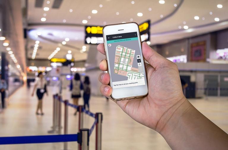
HERE Indoor Radio Mapper is an Android-based tool for collecting geo-referenced radio data on the WiFi access points and Bluetooth beacon signal strengths inside buildings. The tool also supports collecting signal-strength data outdoors in the vicinity of your venue in case smooth indoor/outdoor transitions are required.
To use this tool, you need to have an indoor map of your venue (either a HERE Venue Map or a custom image-based indoor map of your own) and WiFi access points or Bluetooth beacons installed in your building. As soon as you have a map available, you can try out radio data collection and Indoor Positioning in the demo mode in Indoor Radio Mapper. However, if you want to use Indoor Radio Mapper in your own app, you can register for HERE Mobile SDK premium evaluation at our Developer Portal and download our example apps from GitHub.
Radio data collection with the HERE Indoor Radio Mapper is the key to giving HERE Mobile SDK applications location awareness, even inside buildings. The collected radio data is processed in the HERE Cloud to create an understanding of the radio signal behavior within the building. We call this the radiomap of the building. The radiomap is downloaded and used by the HERE Mobile SDK to locate devices running the location-aware application, and provides accuracy within a few meters -- and in full 3D.
Want to see more?
Want to do more? Download the developer kit and get started with your own venue and facility maps for 2018.
Have your say
Sign up for our newsletter
Why sign up:
- Latest offers and discounts
- Tailored content delivered weekly
- Exclusive events
- One click to unsubscribe