-
-
Platform Overview Platform Overview
High-precision data and advanced tooling in one place
-
Maps & Data Maps & Data
Build high-quality maps using fresh location data
Maps & Data-
Map Data Map Data
Create fresh, accurate maps and layer global information
-
Dynamic Map Content Dynamic Map Content
Explore industry-leading map content
-
Maps for ADAS & HAD Maps for ADAS & HAD
Help vehicles see beyond sensors with location data sources
-
-
Services Services
Browse our extensive range of services and APIs
Services-
Routing Routing
Make journey planning easier with our routing portfolio
-
Geocoding & Search Geocoding & Search
Translate addresses into accurate geocoordinates
-
Map Rendering Map Rendering
Highly customizable graphics and real-time map data
-
Positioning Positioning
Pinpoint devices and assets locations with precision
-
-
Tools Tools
Build solutions with our flexible developer tools and applications
Tools-
HERE Studio HERE Studio
Visualize, style and edit location data
-
HERE Workspace HERE Workspace
Create location-centric products and services in one space
-
HERE Marketplace HERE Marketplace
Source, buy, sell and trade location assets
-
HERE SDK HERE SDK
Build advanced location-enabled applications
-
HERE Live Sense SDK HERE Live Sense SDK
Enhance driver awareness by using AI
-
HERE Anonymizer HERE Anonymizer
Maximize location data while supporting regulatory compliance
-
-
Capabilities Capabilities
Everything you need for your location-related use case
Capabilities-
Visualize Data Visualize Data
Identify complex trends and patterns
-
Generate Insights Generate Insights
Transform location data into compelling stories
-
Build Applications Build Applications
Create feature-rich products designed for business
-
Develop Services Develop Services
Produce tailored service experiences
-
Make Maps Make Maps
Create and use custom digital maps
-
-
-
-
By Market By MarketBy Market
-
Automated Driving Automated Driving
-
Connected Driving Connected Driving
-
Fleet Management Fleet Management
-
Supply Chain Supply Chain
-
Urban Mobility Urban Mobility
-
Infrastructure Planning Infrastructure Planning
-
Public Safety Public Safety
-
-
By Applications By ApplicationsBy Applications
-
HERE Last Mile HERE Last Mile
Optimize your last mile deliveries
-
HERE Asset Tracking HERE Asset Tracking
Track assets in real-time with our end-to-end solution
-
HERE Navigation HERE Navigation
Use our off-the shelf navigation system
-
HERE WeGo HERE WeGo
Enjoy your journey with our new navigation app
-
-
-
-
Partner with HERE Partner with HERE
-
Partner Network Partner Network
-
-
Pricing Pricing
-
-
Documentation Documentation
-
Tutorials Tutorials
-
Code Examples Code Examples
-
Knowledge Base Knowledge Base
-
Developer Blog Developer Blog
-
-
-
About us About us
-
Events Events
-
News News
-
Press Releases Press Releases
-
Careers Careers
-
Sustainability Sustainability
-
Leadership Leadership
-
Investors Investors
-
HERE360 Blog HERE360 Blog
-
September 2021 Release Announcement

Highlights
Retrieve data from an interactive map layer in Mapbox Vector Tile format for efficient visualization
Interactive map layers now support the ability to request data in the open, industry standard MVT (Mapbox Vector Tile) format via the interactive API. This data format is also optimized for some data visualization purposes (such as when using Maps API for JS to produce a map within a web application) because the geometries are already projected and simplified specifically for the requested zoom level, thereby reducing the amount of work necessary by a consuming client to render the data.
Share schemas between projects within the same organization (CLI only)
Share schemas between projects within the same organization, facilitating collaboration between teams. As with catalogs, sharing schemas between projects consists of two interactions:
- First, identities with manage access to a schema in a project can now make that schema available to other projects in their organization with "read" permissions. They may choose to make the schema available to specific projects or all projects in their organization.
- Second, once a schema has been made available to a project, identities in the project can link to it. This will allow them to add a schema shared from another project to layers in catalogs created in their project.
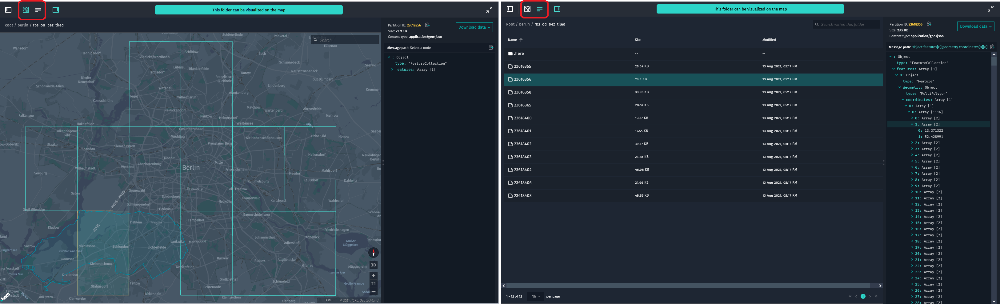
Display data from an object store layer on top of a map
Adding to the layer types fully supported for visual inspection in Data Inspector, and following on from last month's announcement of support for viewing and downloading objects from object store layers in the list view of Data Inspector, you can now visualize an object store layer on a map in Data Inspector by following a few simple conventions. See our Object Store examples in the platform.
Changes, additions, deprecations, and known issues
This blog post focuses on highlights. However, a lot more has happened since our last announcement. Our APIs, SDKs, and tools publish their detailed API level changes in form of changelogs or release notes. For the recent changes, refer to the corresponding changelog or release notes directly:
- HERE Map Rendering
- HERE Geocoding & Search
- HERE Routing
- HERE Real-time Traffic
- HERE Transit
- HERE Positioning
- HERE SDK for Android
- HERE SDK for IOS
- HERE SDK for Flutter
- HERE Map Attributes
- Data API
- Pipeline API
- Marketplace
- Tools
- Data SDKs
Have your say
Sign up for our newsletter
Why sign up:
- Latest offers and discounts
- Tailored content delivered weekly
- Exclusive events
- One click to unsubscribe