-
-
Platform Overview Platform Overview
High-precision data and advanced tooling in one place
-
Maps & Data Maps & Data
Build high-quality maps using fresh location data
Maps & Data-
Map Data Map Data
Create fresh, accurate maps and layer global information
-
Dynamic Map Content Dynamic Map Content
Explore industry-leading map content
-
Maps for ADAS & HAD Maps for ADAS & HAD
Help vehicles see beyond sensors with location data sources
-
-
Services Services
Browse our extensive range of services and APIs
Services-
Routing Routing
Make journey planning easier with our routing portfolio
-
Geocoding & Search Geocoding & Search
Translate addresses into accurate geocoordinates
-
Map Rendering Map Rendering
Highly customizable graphics and real-time map data
-
Positioning Positioning
Pinpoint devices and assets locations with precision
-
-
Tools Tools
Build solutions with our flexible developer tools and applications
Tools-
HERE Studio HERE Studio
Visualize, style and edit location data
-
HERE Workspace HERE Workspace
Create location-centric products and services in one space
-
HERE Marketplace HERE Marketplace
Source, buy, sell and trade location assets
-
HERE SDK HERE SDK
Build advanced location-enabled applications
-
HERE Live Sense SDK HERE Live Sense SDK
Enhance driver awareness by using AI
-
HERE Anonymizer HERE Anonymizer
Maximize location data while supporting regulatory compliance
-
-
Capabilities Capabilities
Everything you need for your location-related use case
Capabilities-
Visualize Data Visualize Data
Identify complex trends and patterns
-
Generate Insights Generate Insights
Transform location data into compelling stories
-
Build Applications Build Applications
Create feature-rich products designed for business
-
Develop Services Develop Services
Produce tailored service experiences
-
Make Maps Make Maps
Create and use custom digital maps
-
-
-
-
By Market By MarketBy Market
-
Automated Driving Automated Driving
-
Connected Driving Connected Driving
-
Fleet Management Fleet Management
-
Supply Chain Supply Chain
-
Urban Mobility Urban Mobility
-
Infrastructure Planning Infrastructure Planning
-
Public Safety Public Safety
-
-
By Applications By ApplicationsBy Applications
-
HERE Last Mile HERE Last Mile
Optimize your last mile deliveries
-
HERE Asset Tracking HERE Asset Tracking
Track assets in real-time with our end-to-end solution
-
HERE Navigation HERE Navigation
Use our off-the shelf navigation system
-
HERE WeGo HERE WeGo
Enjoy your journey with our new navigation app
-
-
-
-
Partner with HERE Partner with HERE
-
Partner Network Partner Network
-
-
Pricing Pricing
-
-
Documentation Documentation
-
Tutorials Tutorials
-
Code Examples Code Examples
-
Knowledge Base Knowledge Base
-
Developer Blog Developer Blog
-
-
-
About us About us
-
Events Events
-
News News
-
Press Releases Press Releases
-
Careers Careers
-
Sustainability Sustainability
-
Leadership Leadership
-
Investors Investors
-
HERE360 Blog HERE360 Blog
-
Anatomy of mapping cars – for dummies

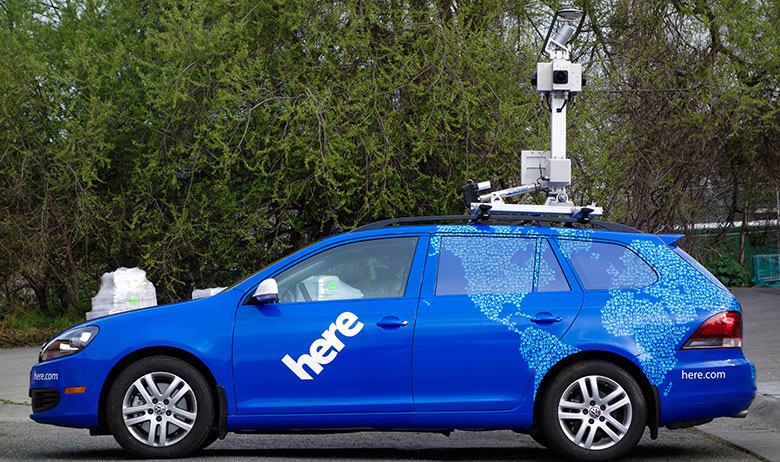
Sightings of a mysterious car saddled with mapping equipment ignited social media and had tech reporters abuzz in February with many questions and less than a few answers. That the unmarked car was registered to Apple undoubtedly spurred much of the curiosity, with some speculating that it was a prototype for an autonomous vehicle, and others proclaiming it as a mapping vehicle.
To better understand what’s what, let’s take a look at the anatomy of our own mapping vehicles, which collect high definition (HD) map data to lay the foundation for a future of self-driving cars.
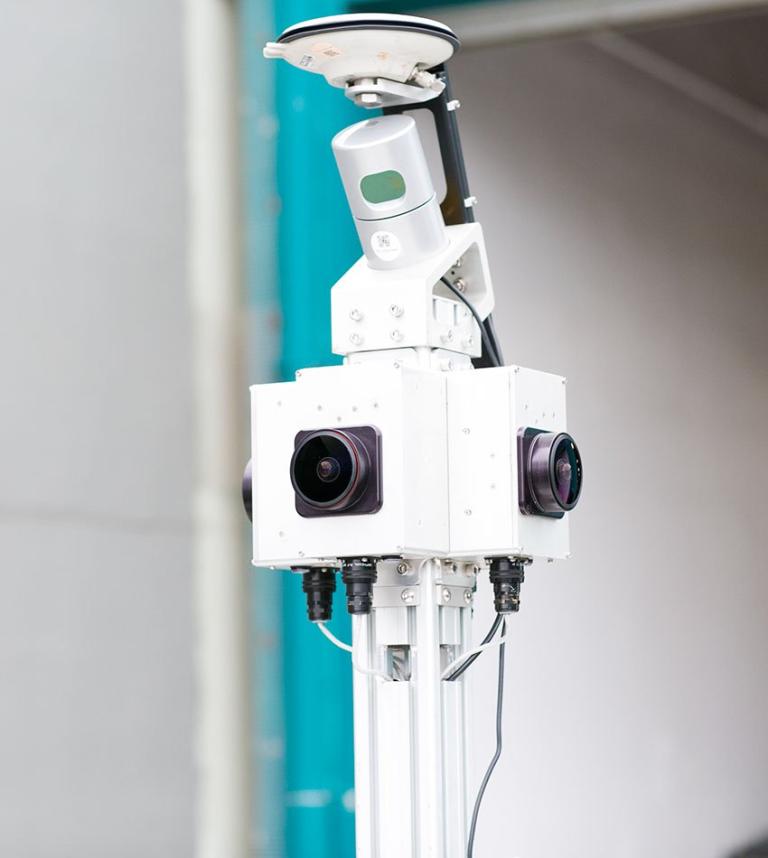
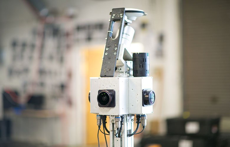
Each of our mapping cars around the world is mounted with a five-foot rig that contains our mapping hardware. At the base, you’ll find an inertial measurement unit (IMU) that collects positions, heading and attitude data (including yaw, pitch and roll) using accelerometers and gyroscopes. This helps us understand the motion of the car driving so we can factor in hills or turns into our data collection.
Further up the rig, our clear street imagery is captured using four wide-angle 24-megapixel cameras for a panoramic (or 360°) view. This allows us to create a more seamless image than competitors, many of whom stitch together images from a dozen street-view cameras.
Up top, a small cylinder that resembles a soda can spins furiously. This piece of hardware is the LiDAR (Light Detection And Ranging) sensor that gathers the data used to build the 3D representation of reality. This rotating laser scanner can collect about 700,000 3D data points per second – pinpointing the edge of a curb, the height of a tree and the depth of a sidewalk. Each week, a single HERE mapping car gathers up to 108 billion of these 3D data points.
Finally, the top of each HERE mapping car is crowned with a high-accuracy global positioning system (GPS), which tracks the coordinates of where the data is captured (i.e. longitude and latitude) to add context to the galaxy of 3D data points collected by the LiDAR and pinpoint exactly where each image was recorded.
At HERE, we’re using this data to prepare for a future of autonomous cars and smarter cities through HD maps. In the past 18 months, HERE has mapped 1.2 million miles (2 million kilometers) of road in 3D and we have mapping cars in the field collecting new data every day.
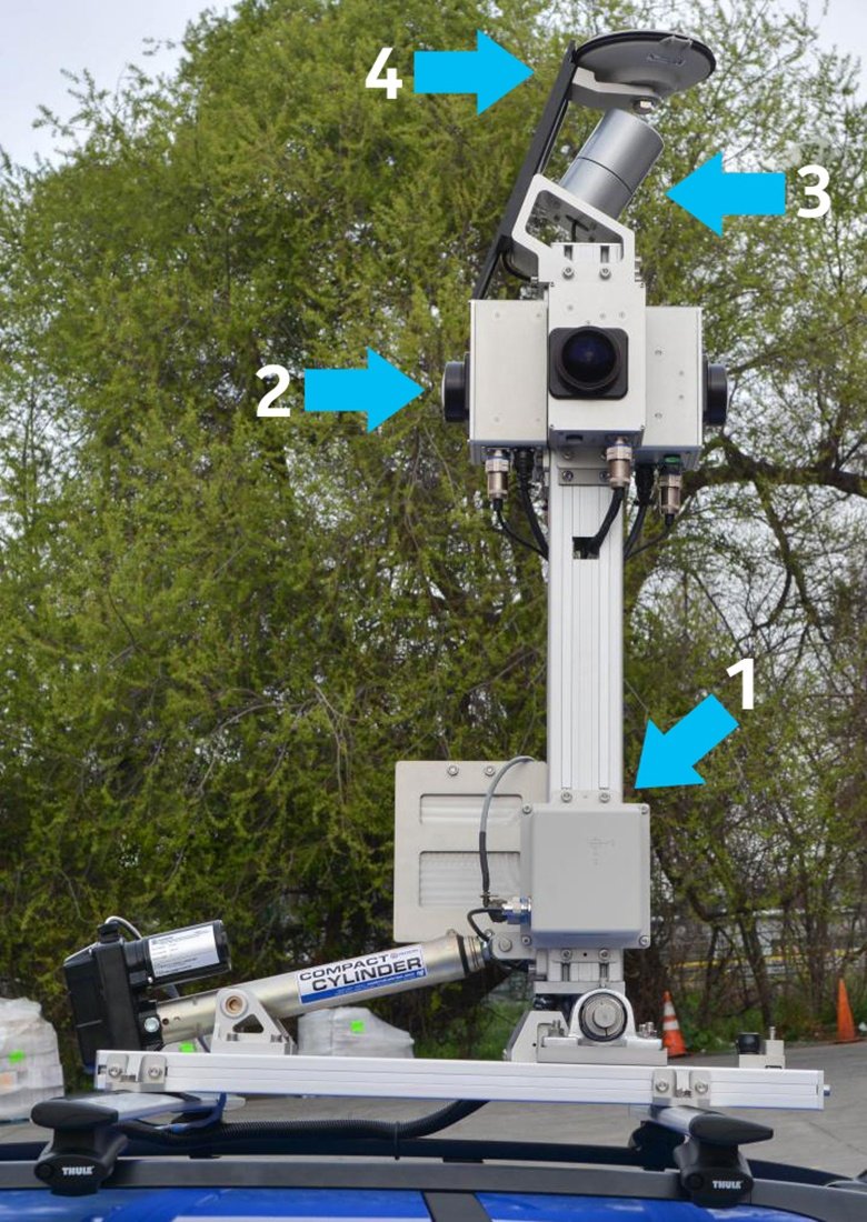
So, let’s see what you’ve learnt. Can you identify the parts of the rig above? Let us know your answers in the comments section below.
Have your say
Sign up for our newsletter
Why sign up:
- Latest offers and discounts
- Tailored content delivered weekly
- Exclusive events
- One click to unsubscribe