-
-
Platform Overview Platform Overview
High-precision data and advanced tooling in one place
-
Maps & Data Maps & Data
Build high-quality maps using fresh location data
Maps & Data-
Map Data Map Data
Create fresh, accurate maps and layer global information
-
Dynamic Map Content Dynamic Map Content
Explore industry-leading map content
-
Maps for ADAS & HAD Maps for ADAS & HAD
Help vehicles see beyond sensors with location data sources
-
-
Services Services
Browse our extensive range of services and APIs
Services-
Routing Routing
Make journey planning easier with our routing portfolio
-
Geocoding & Search Geocoding & Search
Translate addresses into accurate geocoordinates
-
Map Rendering Map Rendering
Highly customizable graphics and real-time map data
-
Positioning Positioning
Pinpoint devices and assets locations with precision
-
-
Tools Tools
Build solutions with our flexible developer tools and applications
Tools-
HERE Studio HERE Studio
Visualize, style and edit location data
-
HERE Workspace HERE Workspace
Create location-centric products and services in one space
-
HERE Marketplace HERE Marketplace
Source, buy, sell and trade location assets
-
HERE SDK HERE SDK
Build advanced location-enabled applications
-
HERE Live Sense SDK HERE Live Sense SDK
Enhance driver awareness by using AI
-
HERE Anonymizer HERE Anonymizer
Maximize location data while supporting regulatory compliance
-
-
Capabilities Capabilities
Everything you need for your location-related use case
Capabilities-
Visualize Data Visualize Data
Identify complex trends and patterns
-
Generate Insights Generate Insights
Transform location data into compelling stories
-
Build Applications Build Applications
Create feature-rich products designed for business
-
Develop Services Develop Services
Produce tailored service experiences
-
Make Maps Make Maps
Create and use custom digital maps
-
-
-
-
By Market By MarketBy Market
-
Automated Driving Automated Driving
-
Connected Driving Connected Driving
-
Fleet Management Fleet Management
-
Supply Chain Supply Chain
-
Urban Mobility Urban Mobility
-
Infrastructure Planning Infrastructure Planning
-
Public Safety Public Safety
-
-
By Applications By ApplicationsBy Applications
-
HERE Last Mile HERE Last Mile
Optimize your last mile deliveries
-
HERE Asset Tracking HERE Asset Tracking
Track assets in real-time with our end-to-end solution
-
HERE Navigation HERE Navigation
Use our off-the shelf navigation system
-
HERE WeGo HERE WeGo
Enjoy your journey with our new navigation app
-
-
-
-
Partner with HERE Partner with HERE
-
Partner Network Partner Network
-
-
Pricing Pricing
-
-
Documentation Documentation
-
Tutorials Tutorials
-
Code Examples Code Examples
-
Knowledge Base Knowledge Base
-
Developer Blog Developer Blog
-
-
-
About us About us
-
Events Events
-
News News
-
Press Releases Press Releases
-
Careers Careers
-
Sustainability Sustainability
-
Leadership Leadership
-
Investors Investors
-
HERE360 Blog HERE360 Blog
-
How we built a map showing monthly ISA data update in EU

As of July 2022, Intelligence Speed Assistance (ISA) is mandatory in the European Union, Norway, and Switzerland on all new-model cars, vans, trucks, and buses. ISA systems source speed limits from on-vehicle sensors, like cameras, which can read speed signs. However, up to 60% of speed limits are not explicitly signposted and are based on implicit signs and would require the freshest map data. Implicit speed limits are road signs that do not show a numerical value (administrative areas, for example) but are based on existing rules and regulations.
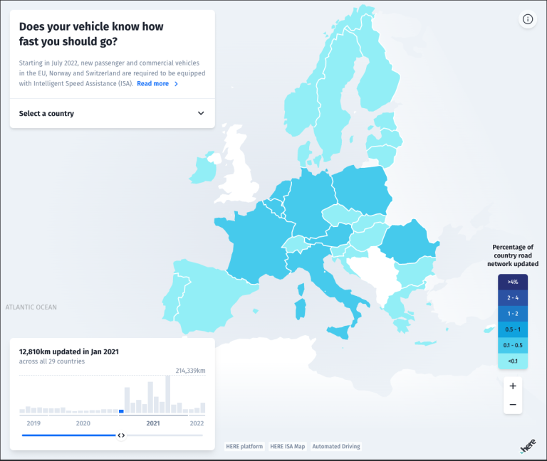
The HERE ISA Map aims to show the percentage of the road network that has been updated by country and month.
Data
This map visualization is based on the data available in the HERE ISA Map and shows the number of monthly map updates in km by the length of the road network across 27 European Union country members, Switzerland and Norway between August 2019 and March 2022. The map also shows more detailed information for each country, such as the split between implicit and explicit speed limit updates, as well as the percentage of a country’s road network with allowed driving speeds.
User Experience and UI
Data on the percentage of the road network that has been updated in a given month is displayed using a thematic choropleth map, where darker shades indicate more changes for the given month.
Users can also see at a glance the absolute number of km that was updated in a given month, and switch the month by moving the slider. More detailed information on a specific country is also available. Users can get information on the split between explicit and implicit updates in a specific country for a given month. Additional information on the percentage of road networks with allowed driving speeds is also displayed in a donut chart.
Embedding the map
The map can be embedded as an iframe, with detailed instructions for desktop and/or mobile devices available under the About modal.
HERE data and products used
This map is based on HERE ISA Map, a reliable and up-to-date speed limit data source for ISA systems. We also used the HERE Javascript API to render the map.
Read more about what is ISA and driving safety with ISA.
Have your say
Sign up for our newsletter
Why sign up:
- Latest offers and discounts
- Tailored content delivered weekly
- Exclusive events
- One click to unsubscribe