How to remove the guesswork out of optimizing your fleet’s operation
If you’re in fleet logistics, keeping vehicles moving is the lifeline of your business. Period. Every dollar earned or lost hinges on getting vehicles from one point to the next, and to the next, as cost-effectively and quickly as possible. The unbearable heaviness of this planning process is made lighter with our Waypoint Sequence Extension.
Imagine you have three vehicles tasked inside of a 1000-square-mile operating area. Two of your drivers are coming off mandatory rest periods, while one will have a required break after the next eight hours of service. You have a dozen pick-up points, three dozen drop-off points with different open/close hours, and each location has a different commercial value. Now factor in traffic, road restrictions, and mileage. What’s the best way to go?
We’re way past solving this by only turning right.
A key starting point to the solution is the Custom Location Extension (CLE). The CLE enables a driver or a manager to see and search a customized list of locations, or custom POIs.
Having that company-owned list of locations is good, in fact it’s great. But managing a fleet at scale needs something more. The task of cost-management needs an algorithm built on top of all of those points and their individual eccentricities. The myriad number of variables that factor into planning cargo transport at scale isn’t something you’ll find ready to go from any other mapping service. That’s why we built the Waypoint Sequence Extension (WSE).

Show me how it works.
We’re deeply familiar with the pain points that planners face, and WSE is a huge step forward in easing them. The example of the three vehicles and drivers above is only the beginning of the challenges and variables that our algorithms solve for.
A driver has a truck, and a mandated set of operating hours. Each truck has a capacity, and a similar operating timeline between maintenance checks and fill-ups. Pick-up and drop-off locations have operating hours. The transit of cargo between them has variable value. The time it takes to load and unload at each individual point will differ.
The traffic on the roads between these points will vary based on the time of day. What’s more, if you’re a planner, you know the restrictions that average drivers aren’t aware of. Roads have rules and ratings for a truck’s maximum vehicle height and weight. There are very serious rules about what types of materials are allowed on certain roads.
All of these small but incredibly important pieces of information are accessed by the WSE. The algorithms we provide don’t simply render a point-to-point travel map, but step beyond into truly optimized planning with all the necessary stops, the commercial value, the traffic, the road restrictions for trucks, and all the operating hours in mind.
Now, a planner has real options. Want to get your trucks moving to maximize the largest number of stops in the shortest available driving time? A fleet manager can request routes optimized by time and distance. That optimized route takes factors into account that the first pickup location opens at 9AM, the fourth opens at noon, and the last two points close at 10PM, with all the points and roads in between.
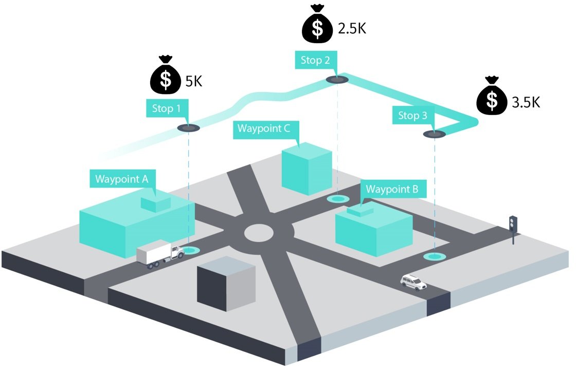
On the other hand, a planner may want to optimize value. Each point in a planner’s library of locations may represent differing potential earning power for the company. A planner can instruct the WSE to prioritize high-earning pick-ups and drop-offs during a route. The WSE intelligently determines the path for optimized earning potential based on cargo, distance and vehicle operating costs.
Of course, both examples factor in underlying information like road restrictions applicable to trucks, traffic, loading and unloading times, and driver hours of service. Those various conditions enable a planner to input buffer times and set alerts if those times are exceeded. If a truck is over its allotted time in the middle of the day, the planner can instruct a driver to make adjustments to meet the most important deadlines before the end of the working day.
With the flexibility of the Waypoint Sequence Extension, we’re transforming detailed data from company operations into a very real picture of how they manage their vehicles. The algorithms solve the complexity of route planning, and improve the bottom line for their fleets.

Sign up for our newsletter
Why sign up:
- Latest offers and discounts
- Tailored content delivered weekly
- Exclusive events
- One click to unsubscribe