Insights & Trends
Thanks to HERE Location Reasoning, your AI knows where it is
HERE Technologies — 14 October 2026
8 min read
09 September 2026
For decades, success in location intelligence depended on better maps: broader coverage, greater accuracy and richer data. That advantage helped businesses plan routes with more confidence, operate logistics networks more efficiently and make location-based decisions on a more trusted foundation.
But the expectations placed on maps have expanded. Businesses operate in a world that is changing faster, increasing the need for maps to stay current. Software-defined vehicles (SDVs) and artificial intelligence (AI) technologies increasingly rely on maps as a source of truth about the physical world, creating new demands for map information to be timely, reliable and usable by machines.
At the same time, businesses increasingly need maps that reflect their own operational reality, from private roads and restricted areas to business-specific assets, workflows and rules.
The challenge for businesses is no longer only whether the map is complete. It is whether their location intelligence can keep up with real-world change and reflect the operational context their business depends on.
Traditional mapmaking was designed for a different era.
The process was linear: collect data, validate it, publish a new version and repeat. At the time, periodic updates reflected both the practical limits of mapmaking technology and the needs of the systems that depended on maps.
That assumption is breaking down.
Today, maps sit at the heart of operational systems. They guide autonomous vehicles, optimize logistics networks, power AI applications and support decisions that happen every second.
Historically, human drivers, operators and planners could compensate for imperfect map information using experience and judgment. Increasingly, that responsibility is shifting to software, AI systems and autonomous technologies. As automation expands across transportation and logistics, maps are no longer just navigation tools. They are becoming a critical source of context for decision-making machines. Confidence in that information therefore becomes essential.
The consequence of a stale map has fundamentally changed. An outdated map is no longer just an inconvenience; it becomes operational risk.
A missed road restriction can disrupt delivery planning. An old road model can compromise automated driving. Limited private or site-specific context can constrain how well an AI system understands what is possible, restricted or preferred in a real operating environment.
As maps move from navigation tools to operational infrastructure, mapmaking must evolve with them.
The challenge is no longer how to build a better map. It is how to build a mapmaking system that continuously learns, adapts and remains aligned with the world they represent.
This shift requires rethinking what mapmaking actually is.
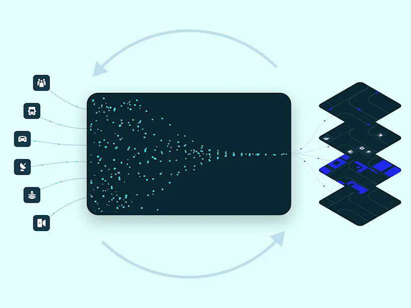
Mapmaking is evolving beyond a traditional production process into a living intelligence system, one that actively captures change, validates observations, enriches context and delivers trusted information that enterprises can act on with confidence.
In this new era, the value of a map comes not only from what it contains, but from how effectively it can learn, adapt and remain aligned with the world it represents.
Modern mapmaking must do three things well: understand the world more completely, keep pace with change and adapt location intelligence to the context of each business.
Three capabilities define modern mapmaking: |
Modern mapmaking requirements | Why it matters | How HERE is evolving mapmaking |
Understanding the real world | Every digital decision depends on an accurate representation of the physical world. | Capturing richer map content, structures, conditions and constraints that shape movement. |
Continuous evolving with the real world | When machines rely on maps as truth, confidence in that information becomes essential. | Detecting, validating and integrating real-world change from vehicles, sensors and connected ecosystems. |
Adapting maps to real operations | Generic maps cannot reflect the unique operational realities that businesses depend on every day. | Enabling enterprises to enrich, customize and govern maps according to their own operational requirements. |
Together, these capabilities present a shift from maintaining maps to continuously understanding the world they describe and enabling organizations to make that understanding operationally relevant.
The volume, velocity and complexity of real-world change have outgrown what human-powered map maintenance alone can manage.
AI and automation are becoming essential infrastructures for modern mapmaking. Applied across the mapmaking lifecycle, they help detect change, fuse signals from multiple sources, automate validation and dramatically reduce the time between an event occurring and the map reflecting it.
More importantly, they are transforming mapmaking from a process of maintaining maps into a capability that continuously understands and responds to real-world change.
The objective remains the same: deliver trusted location intelligence that organizations can rely on to make better decisions.
This transformation is no longer theoretical. It is already underway.
At HERE, we are enabling mapmaking for a world that does not stand still.
Powered by continued investment in AI and automation, we are evolving the capabilities that underpin modern mapmaking. Recent innovations have accelerated new-road detection by 3–12 times and expanded the use of AI and machine learning (ML) to identify more traffic-sign types, helping maps capture more of the real world with greater speed and precision. Strengthened feedback loops now enable daily speed-limit updates and reduce place-update latency to less than 48 hours, narrowing the gap between real-world change and map updates.
At the same time, HERE‘s Custom Attributes enable enterprises to enrich maps with more than 25 operationally relevant road attributes, bringing business-specific constraints, rules and context directly into location intelligence.
These capabilities are designed to do more than improve individual map features. They enable maps to continuously evolve—becoming fresher, more complete, more accurate and more relevant to how organizations operate.
The progress is already measurable. Across the first half of 2026, investment in these developments was translated into measurable improvements across map freshness, completeness and operational relevance, showing how modern mapmaking is turning innovations into tangible benefits that customers rely on.

Every digital decision ultimately depends on an understanding of the physical world.
When maps fall out of sync with reality, every system that depends on them inherits that gap. As AI becomes more capable, vehicles become more autonomous and enterprises become more connected, the ability to keep digital representations aligned with the physical world becomes increasingly critical.
The next generation of value from location intelligence will not come from simply having access to more map data. It will come from using mapmaking systems that capture, validate and operationalize real-world change.
Because the future of maps will not be defined by the map itself. It will be defined by mapmaking.

Menghan Cui
Product Marketing Manager
Share article
HERE Technologies — 14 October 2026
Louis Boroditsky — 09 October 2026
Tomi Agócs — 02 October 2026
Why sign up:
Latest offers and discounts
Tailored content delivered weekly
Exclusive events
One click to unsubscribe