Insights & Trends
Thanks to HERE Location Reasoning, your AI knows where it is
HERE Technologies — 14 October 2026
10 min read
02 October 2026
Artificial intelligence (AI) systems increasingly power applications that demand precise spatial understanding, from autonomous vehicles to logistics optimization and location-based services. That shift exposes a core limitation in how AI models process geographic information. While large language models (LLMs) excel at language prediction and pattern recognition, they do not provide consistently reliable answers about the physical world on their own.
Geospatial grounding is one response to this gap. It anchors AI reasoning to trusted geographic data sources so systems can check their outputs against verified information. But as this article explains, grounding alone still leaves the model attempting spatial reasoning. The more reliable approach removes that attempt entirely.
In this article, we'll explain what geospatial grounding is, why LLMs struggle without it, how it differs from offloading spatial computation and how HERE powers reliable AI across industries.

Read more: Why LLMs understand language but not space
Geospatial grounding refers to the technical process of connecting generative AI outputs to verifiable sources of geographic information. It supplements a model's response with external data so that claims about locations, spatial relationships and physical-world contexts can be confirmed or corrected.
In practice, this means giving AI systems access to structured geospatial data—coordinates, boundaries, points of interest, road networks and real-time conditions—that the model can reference when generating responses. Rather than relying only on patterns learned during training, a grounded AI system retrieves geographic information and checks its output against trusted sources.
The key point is what the model still does. In a grounding pattern, the LLM continues to attempt the spatial reasoning itself. The external data confirms or adjusts the result. That distinction sits at the heart of how HERE approaches this problem, and we return to it below.
Large language models struggle with spatial reasoning because they are designed to predict the next most likely token in a sequence, not to understand or compute geographic relationships.
Ask an ungrounded LLM about the distance between two cities, the fastest route to a destination or what businesses exist near an address, and the model generates a response based on statistical patterns in its training data. It cannot reliably perform actual spatial calculations or consult current geographic databases. This gap between language prediction and true spatial reasoning shows up in predictable ways.
Hallucinated locations are one of the most common failures. An LLM may confidently describe businesses, landmarks or addresses that do not exist, or place real locations in the wrong geographic context. A model might describe a restaurant at an address where no such establishment operates, or provide directions that reference streets in the wrong city.

Read more: Enabling spatial reasoning for LLMs
Grounding primarily provides an AI system with access to trusted external information. The weakness is clear: the model is still applying probabilistic approaches at spatial logic and trying to solve computation it was never built to handle.
Reliable location reasoning, however, is achieved with an execution layer in the middle that aids with specialized spatial logic.
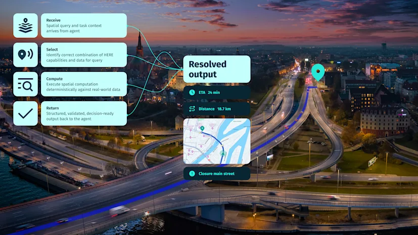
The LLM recognizes that a query involves spatial logic, delegates it to a dedicated execution layer that guides it to break down the query into structured, validated flows. Guided by the execution/reasoning layer, the model never approximates a route, estimates a midpoint or infers a constraint. It hands the spatial problem to the system built to solve it.
In agentic AI systems, a dedicated spatial execution layer can function as the building block that computes location outcomes. It allows access to verified spatial data and provides the spatial logic that lets AI agents take accurate, location-aware actions in the real world.
Agentic AI refers to systems where models do more than generate text. They perform tasks, make decisions and interact with external tools and data sources. In these architectures, an added spatial execution layer can serve as the bridge between the agent's reasoning and the physical world it must navigate.
Consider a driver asking an in-vehicle assistant: "I need to stop for fuel before the motorway section, but only somewhere a seven-meter van can access." Answering this means computing the current route, searching for fuel stations before the motorway entry, filtering by vehicle access constraints and ranking options by actual travel time. None of these steps involve language. Each requires computation over a road network, live location data and map attributes that encode physical constraints.
Ask an LLM for a truck route and it might send a 13-foot rig under a 12-foot bridge, miss a hazmat ban, or promise a charger that's unreachable in real drive-time. Without a dedicated spatial execution layer, "reachable" stays a guess—and guesses don't scale to autonomous decisions.
The execution layer handles exactly this: routing across road graphs, spatial search against live data, constraint validation against authoritative map attributes and multi-step operations. The result is not only more accurate. It is more efficient, meaning that it was resolved in a single tool call to the reasoning layer what would otherwise require many round trips between the model and separate location APIs.
Geospatial grounding and traditional geocoding address distinct technical functions, although both involve associating information with geographic coordinates or locations.
Traditional geocoding is a specific operation: converting a text address or place name into coordinates, or converting coordinates back into a readable address. It answers the question "where is this address located?" with a coordinate pair.
Geospatial grounding is broader. It includes geocoding but extends beyond it, touching questions like "what exists at this location?", "how do these places relate to each other spatially?" and "what conditions currently affect this area?" An autonomous vehicle can convert a destination address into coordinates, but it needs far more than coordinates to navigate safely. It needs to understand road networks, traffic conditions, lane configurations and speed limits. Grounding represents the evolution from simple coordinate lookup toward richer spatial context—but as we've seen, richer context still leaves the model attempting the reasoning unless the computation is offloaded.
A dedicated spatial execution layer lets AI systems deliver accurate, actionable location intelligence across industries where spatial precision shapes operational outcomes.
In logistics and supply chain, effective spatial computation improves route optimization, delivery prediction and fleet management. When AI systems draw routing decisions from verified data about road networks, traffic patterns and real-time conditions, they act on actual geographic constraints. A grounded model might have the data but may misunderstand spatial relationships, access conditions, feasibility, etc; a geocoded system computes it from real distances and reroutes vehicles dynamically when conditions change. Logistics operators cannot afford routes that violate vehicle restrictions, so approximation is not an option.
Without spatial context, agents struggle to reason accurately about roads, zones, constraints, timing, or compliance. This may result in fines for breaching environmental or regulatory zones, driver schedules that violate legal hour requirements, missed ETAs and broken customer commitments—unaffordable in enterprise scenarios
For example, vehicles operating with any level of autonomy require spatial understanding that goes far beyond what an ungrounded or even a grounded model can provide. In-vehicle AI systems rely on an execution layer to understand lane configurations, anticipate road geometry and place sensor data within a known geographic framework. Automotive assistants cannot give drivers directions based on probabilistic inference—they need deterministic answers grounded in live traffic and closures, vehicle-specific constraints like bridge clearances or EV-specific rules, true drive-time reachability, and even perhaps amenities connected to the route itself.
Mapping and location services use the same foundation to power the intelligent features users expect. When someone asks a mapping application for nearby restaurant recommendations, the AI needs computed access to current business data, operating hours and precise locations—not hallucinated suggestions. Across all these domains, the common thread is the need for spatial correctness that AI models cannot generate on their own.
HERE approaches this challenge through HERE Location Reasoning, built as a spatial execution layer rather than a grounding tool. The distinction is deliberate. Where grounding verifies what a model produced, HERE Location Reasoning turns location-dependent requests into structured geospatial operations.
A dedicated spatial execution layer goes beyond supplying context. It helps perform actual spatial operations such as routing, travel-time calculation, reachability analysis and constraint validation in specialized geospatial systems, returning computed results for the agent to use.
The LLM understands intent and orchestrates action. HERE Location Reasoning enables computation of the location outcome. When an AI system delegates a query to HERE Location Reasoning, the result—a distance, a set of nearby points of interest, a compliant route—is computed from authoritative geographic data, not generated from model weights or checked after the fact.
This takes a deterministic approach, which means consistent, verifiable spatial computations rather than probabilistic estimates. HERE Location Reasoning is designed to be called by any agent, using any language model, for any query where location determines the outcome. As AI systems evolve from conversational interfaces into agents that act in the physical world, reliable spatial execution becomes foundational rather than optional.

Tomi Agócs
Senior Writer
Share article
HERE Technologies — 14 October 2026
Louis Boroditsky — 09 October 2026
Menghan Cui — 22 September 2026
Why sign up:
Latest offers and discounts
Tailored content delivered weekly
Exclusive events
One click to unsubscribe