
Connected Driving
EV interest is rising. Now the ownership experience must deliver
Ian Dickson — 21 September 2026
13 min read
17 July 2026
Quick answer: |
|---|
A new HERE Technologies study of 2,400+ riders across six APAC markets reveals that navigation has become mission-critical infrastructure for two-wheeler riders—directly shaping their safety, income and daily mobility. Shyam Shankar Raman, Business Segment Leader for Two Wheelers in APAC at HERE Technologies, breaks down what the data really means. |
"In Europe and the Americas, a motorcycle is most likely a pleasure or leisure vehicle," said Shyam Shankar Raman, Business Segment Leader for Two Wheelers in APAC at HERE Technologies. "Riders use them on weekends to travel from point A to point B, feel the cool air and ride in groups. In APAC, the two-wheeler is an essential daily transport tool."
That distinction shapes everything. Across Indonesia, India, Thailand, Vietnam, China and Japan, two-wheelers are not a lifestyle choice. They are the economy. They carry gig workers through gridlocked city streets, move families between markets and serve as the backbone of last-mile delivery. Understanding how riders in these markets use and depend on navigation is exactly what the recent HERE report "Inside the Two-Wheeler Landscape in APAC" set out to explore.
Industry experts consulted during the study consistently described navigation as "infrastructure," not a product feature. Riders only notice it when it breaks. When it works, it quietly sustains flow, income and safety throughout the working day.
"Navigation is judged by whether it keeps deliveries flowing and reduces unnecessary detours in dense traffic," said Abhijit Sengupta, General Manager for Southeast Asia and India at HERE. That standard, defined by outcomes rather than innovation, runs through every market the study examined.
Only 18% of surveyed riders across the six markets reported no routing issues in the four weeks before the survey. The most common problem was poor GPS signal, cited by 40% of riders. Routes leading to non-existent roads, missing alleyways, inaccurate motorbike-specific routing and delayed traffic updates followed closely behind. These aren't edge cases. They represent the daily friction that costs riders time, money and confidence.
"Poor GPS signal was the most surprising finding for me," said Raman. "We had assumed connectivity was largely resolved. But even today, between 40 and 50% of problems were attributed to riders simply not getting GPS signal. That took us one step behind what we had conceived. It makes offline map capability much more significant than I would have expected."

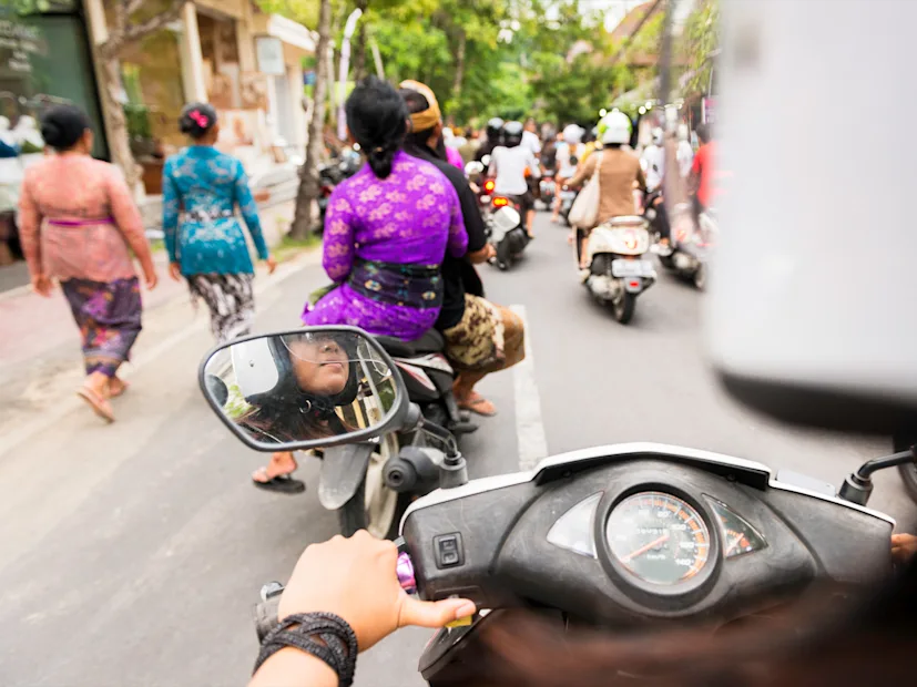
Two-wheelers are the backbone of daily life across APAC, powering gig work, family journeys and last-mile delivery in some of the world’s busiest markets.
No market illustrates the economic stakes of navigation more directly than Indonesia. With around six million two-wheelers entering the market each year—and Jakarta recently claiming the title of the world's most populous urban center—riders navigate some of the most complex road environments on Earth.
48% of Indonesian riders use navigation often or always. For delivery workers, every detour compounds. Inaccurate ETAs ranked as their biggest challenge, followed by delays from poor routing and unsafe shortcuts suggested by navigation systems. 31% of Indonesian delivery riders cited reliable ETAs and safe route suggestions as their single top requirement—the highest preference recorded across all six markets.
"In Indonesia, a wrong turn costs five or ten minutes," said Raman. "At the end of the day, that loops back into earnings."
Voice guidance ranked as the most valued navigation feature overall, cited by 67% of riders. With helmet use comparatively high and smartphones mounted on handlebars, voice alerts delivered through Bluetooth headphones let riders keep their eyes on the road in some of the noisiest, most congested conditions in the region.
35% of Indonesian riders also said navigation capability influences their choice of new two-wheeler, a signal that digital functionality is becoming embedded in purchase decisions, not just in daily use.

What makes Thailand distinctive is the weight riders place on hazard awareness. 51% rely on weather and hazard updates—the highest level of any country in the study.
Thailand's riding environment presents a different mix of pressures. The market is smaller than Indonesia's—closer to two million vehicles per year—and more mature. Route optimization ranked as the most valued navigation feature, cited by 65% of riders. A full-screen map view came second.
What makes Thailand distinctive is the weight riders place on hazard awareness. 51% rely on weather and hazard updates—the highest level of any country in the study. 71% said potholes or broken road surfaces make them feel unsafe, and 69% pointed to large trucks and buses as a major source of stress on the road.
"Thai riders navigate a complex mix of traffic, weather and road conditions every day," Sengupta noted. "Riders place strong value on navigation that helps them anticipate risks and navigate safely through unpredictable conditions." Delivery riders in Thailand reinforced that priority. Multi-stop routing optimization ranked as their top need, chosen by 32%, followed by safer route suggestions at 24% and accurate ETAs at 18%.
Raman describes Thailand as a market where riders are looking to exploit the full potential of navigation, not just use it to get from A to B. "Users are preferring large-screen map rendering. It doesn't need to be embedded—it can be streamed from a mobile phone into a larger UI-based display. Thailand categorized requirements around route optimization and exploiting the display for a map view."

"Buildings are sprung up in packs in dense, populated areas," said Raman. "Historic quarters, expanded cities and old districts pack businesses into tight spaces with narrow streets. That becomes a big challenge for gig workers who need to find the exact entrance."
Vietnam's major cities—Ho Chi Minh City and Hanoi in particular—rank among the most congested in the region. 50% of Vietnamese riders use navigation often or always. Route optimization was the most valued feature at 62%, followed closely by voice navigation at 60%.
The challenges facing delivery workers there go deeper than traffic. Informal addressing, dense concentrations of buildings packed into narrow alleys and bylanes, and an absence of standardized location data make the final meters of a delivery genuinely difficult. "Difficulty finding building entrances" ranked as the third biggest challenge for gig workers after poor routing and inaccurate ETAs.
"Vietnamese riders are navigating some of the most crowded and rapidly changing road conditions in APAC," said Munish Kumar Verma, Head of Auto for Southeast Asia at HERE Technologies. "Navigation earns trust when it reduces uncertainty, protects income and leads riders directly to the right location."
"Vietnam has a very unique topology," said Raman. "Buildings are sprung up in packs in dense, populated areas. Historic quarters, expanded cities and old districts pack businesses into tight spaces with narrow streets. That becomes a big challenge for gig workers who need to find the exact entrance." 22% of Vietnamese riders said navigation performance now influences which two-wheeler they purchase.
The structural trends shaping APAC's two-wheeler market over the next several years are already visible in the data. 31% of surveyed riders across all six markets already own an electric motorbike or scooter. In India alone, out of 18 million vehicles entering the market, around two million are now electric vehicles (EVs), a figure that continues to grow faster than overall industry growth.
"EVs have already gone premium from day one," said Raman. "They come with Android dashboards built in. That means wider embedded maps, better UI and larger visual map rendering is already part of the vehicle architecture." That, he explained, is accelerating the shift toward embedded navigation across the broader market. What was once a high-end feature is becoming a default expectation and connectivity rates—currently below 30% across the entire vehicle population—are expected to exceed 50% within three to four years.
For mid-segment vehicles—priced between $1,500 and $2,000 and representing the fastest-growing part of the market—the focus is on making embedded navigation viable on affordable hardware. New display technologies, specifically thin-film transistor (TFT) screens capable of full-color graphical user interface (GUI) rendering, are creating the conditions for this shift, even on devices with limited processing power and memory.
Advanced Rider Assistance Systems (ARAS) are also moving from concept to early deployment. "We don't have clear timelines on ARAS,” Raman acknowledged, “but advanced rider assist might come through one or two automakers in the next couple of years through test vehicles and pilot launches, before becoming mass production maybe four to five years down the line.” The step before physical intervention—the kind cars already offer—is awareness. Navigation systems that warn riders about incident hotspots, sharp curves, potholes and hazardous weather represent the logical starting point.
Offline maps, meanwhile, are emerging as a more urgent priority than the industry had assumed. In rural and semi-urban areas, and particularly for mid-segment adventure riders heading into mountainous terrain, connectivity cannot be guaranteed. “Everyone focuses on online,” said Raman. “But there is a significant number of riders who are not typical commuters. Our product needs to fit more than one segment.”
The HERE report offers a clear challenge to product teams: build for the conditions riders actually face, not for the infrastructure that exists in more developed markets. Accurate ETAs, two-wheeler-specific routing that accounts for alleys, bylanes and informal roads, and last-mile POI coverage that reaches building-level precision—these are the foundations of a navigation system that genuinely serves APAC riders.
HERE Technologies, in partnership with Point Consulting, surveyed more than 2,400 two-wheeler riders across China, India, Indonesia, Japan, Thailand and Vietnam in Q1 2026. The study examined navigation usage patterns, safety perceptions, economic impact for gig workers and feature priorities across both commuter and delivery segments.
In Europe and North America, two-wheelers are primarily used for leisure and weekend riding. In APAC, they are essential daily transport—used by gig workers, delivery riders and families for commuting and commerce. Navigation directly affects earnings, making accuracy and reliability a livelihood issue rather than a convenience preference.
In Indonesia, inaccurate ETAs and poor routing in dense urban traffic are the top concerns, particularly for delivery workers. In Thailand, hazard awareness, unsafe shortcuts and unpredictable road conditions drive rider priorities. In Vietnam, imprecise last-mile addressing and difficulty locating building entrances present the most acute operational challenges for gig and delivery workers.
31% of surveyed riders already own an electric motorbike or scooter. As EV adoption accelerates, navigation systems will need to incorporate range-aware routing, verified charging point data and battery optimization guidance. EVs are also driving faster adoption of embedded navigation because they tend to launch with Android-based dashboards from the outset, raising the baseline expectation for display quality and mapping capability.
ARAS are safety features that warn riders about hazards, sharp curves, incident hotspots and road conditions—the two-wheeler equivalent of automotive ADAS. Unlike cars, two-wheelers currently lack sensors, cameras and automated safety systems. Pilot launches from one or two manufacturers are expected within the next couple of years, with mass production timelines of four to five years, according to Shyam Shankar Raman of HERE Technologies.
Poor GPS signal was the most commonly reported routing problem in the study, cited by 40% of riders. In rural, semi-urban and mountainous areas, connectivity cannot be guaranteed. Offline maps ensure navigation remains functional regardless of network availability—a critical feature for commuters, adventure riders and delivery workers operating in areas with unreliable coverage.

Louis Boroditsky
Managing Editor, HERE360
Share article
Ian Dickson — 21 September 2026
Louis Boroditsky — 22 July 2026
Louis Boroditsky — 01 July 2026
Why sign up:
Latest offers and discounts
Tailored content delivered weekly
Exclusive events
One click to unsubscribe