
Release notes
June 2026 Platform Release Notes
Mohini Todkari — 16 June 2026
5 min read
29 March 2019

All services receive map content updates frequently but we will call out a few noteworthy highlights in March 2019 related to the following services: Routing API and Mobile SDKs.
There were other minor updates and fixes across many other services as well which were related to regular maintenance releases. View the API Version History for specific monthly updates including change log and release notes for all of the APIs.
Also be sure to check out the Top Feature Enhancements Driven by HERE XYZ Beta Participants.
Routing API
Provide precise instructions to a destination using various transport modes (e.g., car, truck, public transit, bicycle) and leveraging different algorithms (e.g., matrix, isoline routing). Learn more…
Version 7.2.102
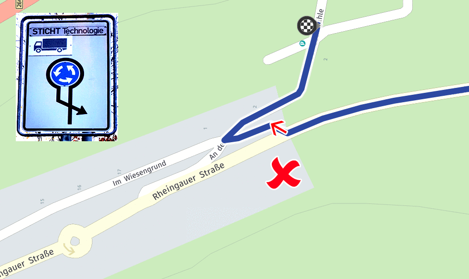
We have improved routing behavior when parameter “avoidTurns=difficult” is used to also avoid difficult sharp turns (in addition to earlier released avoidance of complex U-turns on multi-digitized roads)
Here's an example scenario for a path to avoid a sharp turn by taking the traffic circle, rotary, rotunda, or island.
Mobile SDKS
Full-featured, native apps with our mapping platform. Learn more…
Map Updates
Added support for more detailed information of the long truck available turns. This feature will give possibility to take into account long truck specific turns and restrictions information while creating a Long truck specific route.
Improved definition for Inconvenient maneuver that includes angle between the roads. Improved definition for Inconvenient maneuvers with time restrictions.
Inclusion of basic Scouter routing attributes for routing use cases.
Fixed issue when some Bahrain “Blocks” cities shown on the map on high scale (20KM)
Added support of POIs of “Winery” category
Fixed issue with EV charging station POIs duplication
Updated EarthCore Buildings and Landmarks
Here's an example of creating a category filter for a winery.
NSArray* categories = [[NMAPlaces sharedPlaces] topLevelCategories];
for (id category in categories) {  if (category.uniqueId == "winery" )   {     NMACategory* restCategory = category;    NMAGeoCoordinates* murphys = [[NMAGeoCoordinates alloc]    	initWithLatitude:38.08603        longitude:-120.48867];             NMACategoryFilter *categoryFilter = [NMACategoryFilter new];    [categoryFilter addCategoryFilterFromUniqueId:restCategory.uniqueId];        NMADiscoveryRequest* request = [ [NMAPlaces sharedPlaces]    	createHereRequestWithLocation:murphys filters:categoryFilter];     //...   }}
This category was already available through our Places REST API, but now it's also available on mobile including while navigating offline.
Full-featured, native apps on iOS with our mapping platform. Learn more…
Premium Edition Version 3.10.1
Introduced the “fast” speed profile for trucks
Enabled Turn by Turn guidance for bike routes
Implemented possibility to set/get course for all waypoints on the route
Added error reporting when re-routing fails
Added possibility to customize stopover reached callback
Added feature to retrieve distance on route
Added feature to specify wait time for each waypoint
Added possibility to retrieve TTA for specific subleg
AutoSuggests feature supports offline mode
Added API to retieve remaining distance during guidance
Added possibility to customize upcoming part of the route
Added ability to configure cache size (256MB - 2GB)
Implemented maneuver restrictions on motorcycle turn cost tables
Fixed positioning latency issue
Improved MapLoader stability
Added support for new iPads Pro
Added possibility to retieve route element by duration
Enhanced difficult turns avoidance for trucks by excluding sharp turns from a route
Enhanced routing options to exclude specified routing zones (such as environmental zones) from the calculated route as a Beta feature.
Implemented avoidance of odd/even and time dependent environmental zones
Full-featured, native apps on Android with our mapping platform. Learn more…
Premium Edition Version 3.10.1
Introduced the “fast” speed profile for trucks
Enabled Turn by Turn guidance for bike routes
Implemented possibility to set/get course for all waypoints on the route
Added error reporting when re-routing fails
Added possibility to customize stopover reached callback
Added feature to retrieve distance on route
Added feature to specify wait time for each waypoint
Added possibility to retrieve TTA for specific subleg
Autosuggest is now supported for offline mode
Added feature to retrieve remaining distance during guidance
Added possibility to customize upcoming part of the route
Added ability to configure cache size (256MB – 2GB)
Implemented maneuver restrictions on motorcycle turn cost tables
Fixed positioning latency issue
According to changes in Android API 28 with deprecation of android.app.Fragment corresponding Mobile SDK API is marked as deprecated com.here.android.mpa.mapping.MapFragment and new API introduced com.here.android.mpa.mapping.SupportMapFragment instead. For more information see official Android documentation.
Improved map representation in Mercator Projection
Simplified creation of MapMarker objects
Enhanced difficult turns avoidance for trucks by excluding sharp turns from a route
Implemented avoidance of odd/even and time dependent environmental zones

Jayson DeLancey
Share article
Why sign up:
Latest offers and discounts
Tailored content delivered weekly
Exclusive events
One click to unsubscribe

