What's New in Maps API for JavaScript?
A number of new features have been added to the recent update of our Maps API for JavaScript. In addition to various performance and quality enhancements, there are some features we would like to highlight that you might also benefit from now. This post is going to cover the following:
- Improvements to vector tile rendering
- Integration of public transit options
- Better support for popular developer environments
- Applications to explore using Maps API for JavaScript
Improvements to Vector Tile Rendering
We want to spotlight some notable improvements to the Vector Tile API, which is accessible from the Maps API for JavaScript, when a map is initialized with vector tile layers.
Support for country specific road shields
A “road shield” is how we identify major roads or highways. In the following screen captures, the road shields shown are specific to their respective countries. Developers get access to this feature by default.
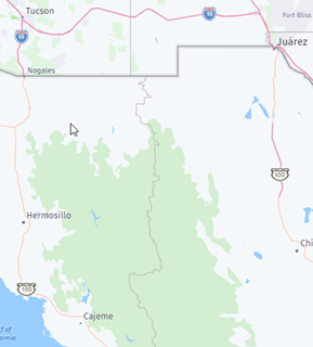
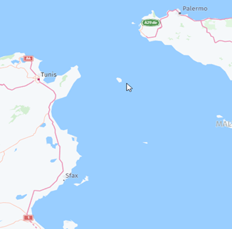
Border of USA and Mexico Tunisia and Sicily
Simplification to render political views
It’s not every day one can say a political view has been simplified. However, when it comes to map rendering, we’ve made it easy to establish potentially disputed boundaries and how you want them to appear in your solutions. The image below is the international view (default) of South Patagonia. The dashed border indicates a current border dispute.
If a developer wants to show the border from the perspective of one country specifically, a request can be made to show that. For more information, see how to use the geopolitical views.
Integration of the Public Transit Options
The Public Transit API (V8) allows you to use agency data, external services and data collected by HERE to discover public transit options and request public transit routes and transit-related information. This API is now accessible from the Maps API for JavaScript via H.servicer.publicTransit class, making it easier for developers to quickly integrate public transit options into their solutions.
Support for Popular Developer Environments
It is now easier to use Maps API for JavaScript in various environments.
Jupyter – AWS SageMaker makes use of Jupyter Notebooks in the machine learning process. With the launch of HERE Maps Widget for Jupyter, it’s easier to establish a link to the Maps API for JavaScript in that environment. Prior to the widget release, it was more cumbersome and timely to utilize location services within a Jupyter Notebook.
React – With the popularity of React, we have improved our documentation for setup and best practices All in one location, developers can quickly discover how to configure environment, add static map component, and how to use common features, and how to make the map interactive.
Applications to Explore Using Maps API for JavaScript
If you would like to explore some examples of maps built using the Maps API for JavaScript, please check out the following:
- Do you live in a “15-minute” city?
An interactive map which allows a user to see if a location has essential living needs within a 15 minute walking or driving distance. - COVID-19 response and vaccination policy tracker
A map with a global view of countries response to COVID-19 and what level of vaccination policy is in affect.
Summary
As more updates are made available, we’ll be sure to keep you posted. In the meantime, we invite developers to evaluate these new features and if you’re new to HERE APIs, please sign up for a freemium account and start playing with our location services APIs today!

Have your say
Sign up for our newsletter
Why sign up:
- Latest offers and discounts
- Tailored content delivered weekly
- Exclusive events
- One click to unsubscribe