-
-
Platform Overview Platform Overview
High-precision data and advanced tooling in one place
-
Maps & Data Maps & Data
Build high-quality maps using fresh location data
Maps & Data-
Map Data Map Data
Create fresh, accurate maps and layer global information
-
Dynamic Map Content Dynamic Map Content
Explore industry-leading map content
-
Maps for ADAS & HAD Maps for ADAS & HAD
Help vehicles see beyond sensors with location data sources
-
-
Services Services
Browse our extensive range of services and APIs
Services-
Routing Routing
Make journey planning easier with our routing portfolio
-
Geocoding & Search Geocoding & Search
Translate addresses into accurate geocoordinates
-
Map Rendering Map Rendering
Highly customizable graphics and real-time map data
-
Positioning Positioning
Pinpoint devices and assets locations with precision
-
-
Tools Tools
Build solutions with our flexible developer tools and applications
Tools-
HERE Studio HERE Studio
Visualize, style and edit location data
-
HERE Workspace HERE Workspace
Create location-centric products and services in one space
-
HERE Marketplace HERE Marketplace
Source, buy, sell and trade location assets
-
HERE SDK HERE SDK
Build advanced location-enabled applications
-
HERE Live Sense SDK HERE Live Sense SDK
Enhance driver awareness by using AI
-
HERE Anonymizer HERE Anonymizer
Maximize location data while supporting regulatory compliance
-
-
Capabilities Capabilities
Everything you need for your location-related use case
Capabilities-
Visualize Data Visualize Data
Identify complex trends and patterns
-
Generate Insights Generate Insights
Transform location data into compelling stories
-
Build Applications Build Applications
Create feature-rich products designed for business
-
Develop Services Develop Services
Produce tailored service experiences
-
Make Maps Make Maps
Create and use custom digital maps
-
-
-
-
By Market By MarketBy Market
-
Automated Driving Automated Driving
-
Connected Driving Connected Driving
-
Fleet Management Fleet Management
-
Supply Chain Supply Chain
-
Urban Mobility Urban Mobility
-
Infrastructure Planning Infrastructure Planning
-
Public Safety Public Safety
-
-
By Applications By ApplicationsBy Applications
-
HERE Last Mile HERE Last Mile
Optimize your last mile deliveries
-
HERE Asset Tracking HERE Asset Tracking
Track assets in real-time with our end-to-end solution
-
HERE Navigation HERE Navigation
Use our off-the shelf navigation system
-
HERE WeGo HERE WeGo
Enjoy your journey with our new navigation app
-
-
-
-
Partner with HERE Partner with HERE
-
Partner Network Partner Network
-
-
Pricing Pricing
-
-
Documentation Documentation
-
Tutorials Tutorials
-
Code Examples Code Examples
-
Knowledge Base Knowledge Base
-
Developer Blog Developer Blog
-
-
-
About us About us
-
Events Events
-
News News
-
Press Releases Press Releases
-
Careers Careers
-
Sustainability Sustainability
-
Leadership Leadership
-
Investors Investors
-
HERE360 Blog HERE360 Blog
-
February Release Highlights Including Searching for Fast Food Snack Places by Distance

All services receive map content updates frequently but we will call out a few noteworthy highlights in February 2019 related to the following services: Places API, Traffic API, and Fleet Telematics API.
There were other minor updates and fixes across many other services as well which were related to regular maintenance releases. View the API Version History for specific monthly updates including change log and release notes for all of the APIs.
Places API
Find (e.g., search for name, type, category), discover (e.g., look into address, contact info) and interact with POI information (e.g., enable user reviews, photos). Learn more…
Version 2.70.0
- Query results for category “snacks-fast-food” are now sorted by distance.
Example
If you take the Discovering Places example for Category Searches:
// H.service.Platform already initialized with app id / code
var explore = new H.places.Explore(platform.getPlacesService());
var params = {
'cat': 'snacks-fast-food',
'at': '39.82596,-105.14587',
'size': '10'
};
explore.request(params, {}, onResult, onError);
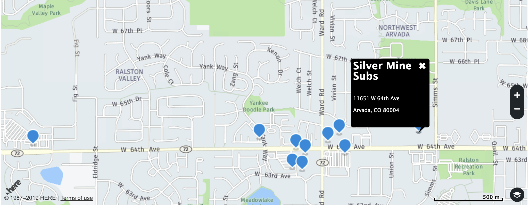
The Explore Entrypoint will typically order results for a category by popularity. Given the nature of snacks and fast food, it may make more sense to order by distance.
The following results (title, distance in meters, and position) were returned for the `snacks-fast-food` category of places near the Apex Center in Arvada, CO:
('Panera Bread', 1427, [39.813306, -105.143065])
('Burger King', 1563, [39.81263, -105.14005])
('Firehouse Subs', 1594, [39.8136, -105.13641])
("Arby's", 1602, [39.81311, -105.13738])
('Taco Bell', 1619, [39.81232, -105.13924])
("Jimmy John's", 1687, [39.81139, -105.14035])
('Chipotle', 1721, [39.81127, -105.13953])
('Subway', 1739, [39.81231, -105.13594])
('Silver Mine Subs', 1931, [39.81372, -105.12983])
("Wendy's", 1996, [39.81292, -105.16193])
Traffic API
Display map tiles with real-time traffic flow information overlays reflected as colored lines drawn on affected streets and roads and get access to real-time traffic flow and incident data in XML and JSON. Learn more…
Version 6.0.85.5
- Introduction of incidents coverage for the following new markets: Lithuania (E2C43), Thailand (F3219), Mexico (A5F36), Taiwan (F1D13), Portugal (E4842), Romania (E1E01), and Bulgaria (E1801)
Fleet Telematics API
Get access to advanced location algorithms for fleet management use cases like geofencing, route matching, toll costs and more. Learn more...
Version 2.5.11
- New routing feature
&excludeCountries=DEU,NLD
by using 3 letter ISO country codes prevents routes from crossing borders into specific countries.
Have your say
Sign up for our newsletter
Why sign up:
- Latest offers and discounts
- Tailored content delivered weekly
- Exclusive events
- One click to unsubscribe