How the HERE ISA Map delivers speed data privately and anonymously?
In July 2022, Intelligent Speed Assist (ISA) has become mandatory for all new car models and vehicle types in the European Union. HERE ISA Map provides reliable and up-to-date speed limit data to support legal compliance and driver safety. What exactly is ISA data, how does it land in our cars, and what are the privacy implications?
HERE ISA Products
- HERE Map content supports ISA solutions with explicit and implicit speed limits.
- HERE Automotive Products provide automotive-ready publications in NDS.Classic and NDS.Live standards to enable ISA & ADAS software.
- With HERE Speed Limit Layer, we have a connected solution offering explicit and implicit speed limits with road network reference – updated daily. This can also be consumed as add-on to navigation map data.
Speed Limit Data Capture
The HERE collection fleet is equipped with several sensors to capture the ground truth. Amongst these are GPS antennas and cameras. A GPS antenna is used to know where our vehicles have captured data from. Cameras capture the footage of the roads driven, in order to know where speed limit signs are, where a Built-Up Area starts/end, etc. These also capture information that goes beyond the ISA regulation, that enhances the overall driver experience (like advisory speed limits, time & weather-based speed limit information, etc.). The footage captured follows a strict process to ensure compliance with (local) legislation, like blurring faces and license plates.
Other inputs are also used to determine the speed limit on a road, amongst which are car sensors and probe data. Car sensor data is the information that an in-vehicle camera has detected on a road sign. With such information, it is possible to overlay the value of the detection (e.g., a 30 km/h sign) at the location of detection (coming from the GPS coordinates from the sensor data). These detections are used to validate the correctness of the speed limit. In case of a mismatch between the map data and the detected value, it can be used for updating the speed limits.
Probe data constitutes of anonymous GPS data points with a time stamp, heading and speed, etc. This is generated by monitoring individual vehicles (i.e., probes) over space and time. These are also not connected to an individual, vehicle, device, etc. Such data provides insight into the speed on a stretch of road and can be compared to the speed limit in the map data. In case of a mismatch, this also triggers action for review and updates.
Privacy and Data Protection
GDPR compliance is part of each step of the collection process and therefore the information cannot be tied back to an individual. None of the insights are shared with other parties; they are solely used for verifying the data available in the map products. For example, the trends of the average vehicle speed on a certain road are not shared with law enforcement.
This map visualization is based on the data available in the HERE ISA Map and shows the number of monthly map updates in km by length of the road network across 27 European Union country members, Switzerland and Norway between August 2019 and March 2022.
Anonymized Data Processing
A limited amount of people has access to the captured data, and this data is blurred and anonymous. Most of the data processing happens automatically, like detected speed limits from the data are compared automatically and processed where needed. Only a limited subset of the data cannot be processed automatically and is reviewed manually by trained staff. These people have access to the captured data in order to determine what action needs to be taken in the map data and update the speed limit accordingly. The data available is blurred / anonymized captured information, so even during processing, there is no option to derive any personal information.
Data Usage
As per ISA regulation, the vehicle sensor is used to determine the speed limit on the road. This can be supported by our electronic map data, which supports speed limit data for all roads. The software in the vehicle will define how the information from the vehicle sensors and the map data will be combined, what preference is given to each, how it deals with conflicting information, etc. This data fusion process can be different per vehicle type or system used.
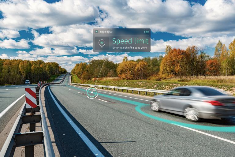
ISA uses the car’s cameras and HERE map data to determine if the car is driving over the speed limit. If so, there are several options for feedback to the driver:
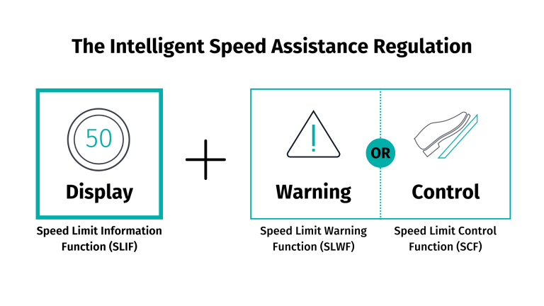
- A Speed Limit Information Function (SLIF) will simply display the currently effective speed limit to the driver.
- A Speed Limit Warning Function (SLWF) will warn drivers using visible and/or audible alters when the speed limit is being exceeded. Drivers then decide themselves whether or not to slow down. It is an informative or advisory system only.
- A Speed Limit Control Function (SCF) limits the vehicle’s speed to the speed limit. Driving slower is easily possible by putting less pressure on the accelerator pedal and the system may allow drivers to go faster than the speed limit allows by pressing down on the accelerator with more force than usually needed to overwrite the SCF.
Read more about what is ISA and driving safety with ISA.

Have your say
Sign up for our newsletter
Why sign up:
- Latest offers and discounts
- Tailored content delivered weekly
- Exclusive events
- One click to unsubscribe