-
-
Platform Overview Platform Overview
High-precision data and advanced tooling in one place
-
Maps & Data Maps & Data
Build high-quality maps using fresh location data
Maps & Data-
Map Data Map Data
Create fresh, accurate maps and layer global information
-
Dynamic Map Content Dynamic Map Content
Explore industry-leading map content
-
Maps for ADAS & HAD Maps for ADAS & HAD
Help vehicles see beyond sensors with location data sources
-
-
Services Services
Browse our extensive range of services and APIs
Services-
Routing Routing
Make journey planning easier with our routing portfolio
-
Geocoding & Search Geocoding & Search
Translate addresses into accurate geocoordinates
-
Map Rendering Map Rendering
Highly customizable graphics and real-time map data
-
Positioning Positioning
Pinpoint devices and assets locations with precision
-
-
Tools Tools
Build solutions with our flexible developer tools and applications
Tools-
HERE Studio HERE Studio
Visualize, style and edit location data
-
HERE Workspace HERE Workspace
Create location-centric products and services in one space
-
HERE Marketplace HERE Marketplace
Source, buy, sell and trade location assets
-
HERE SDK HERE SDK
Build advanced location-enabled applications
-
HERE Live Sense SDK HERE Live Sense SDK
Enhance driver awareness by using AI
-
HERE Anonymizer HERE Anonymizer
Maximize location data while supporting regulatory compliance
-
-
Capabilities Capabilities
Everything you need for your location-related use case
Capabilities-
Visualize Data Visualize Data
Identify complex trends and patterns
-
Generate Insights Generate Insights
Transform location data into compelling stories
-
Build Applications Build Applications
Create feature-rich products designed for business
-
Develop Services Develop Services
Produce tailored service experiences
-
Make Maps Make Maps
Create and use custom digital maps
-
-
-
-
By Market By MarketBy Market
-
Automated Driving Automated Driving
-
Connected Driving Connected Driving
-
Fleet Management Fleet Management
-
Supply Chain Supply Chain
-
Urban Mobility Urban Mobility
-
Infrastructure Planning Infrastructure Planning
-
Public Safety Public Safety
-
-
By Applications By ApplicationsBy Applications
-
HERE Last Mile HERE Last Mile
Optimize your last mile deliveries
-
HERE Asset Tracking HERE Asset Tracking
Track assets in real-time with our end-to-end solution
-
HERE Navigation HERE Navigation
Use our off-the shelf navigation system
-
HERE WeGo HERE WeGo
Enjoy your journey with our new navigation app
-
-
-
-
Partner with HERE Partner with HERE
-
Partner Network Partner Network
-
-
Pricing Pricing
-
-
Documentation Documentation
-
Tutorials Tutorials
-
Code Examples Code Examples
-
Knowledge Base Knowledge Base
-
Developer Blog Developer Blog
-
-
-
About us About us
-
Events Events
-
News News
-
Press Releases Press Releases
-
Careers Careers
-
Sustainability Sustainability
-
Leadership Leadership
-
Investors Investors
-
HERE360 Blog HERE360 Blog
-
Closing the loop: BMW cars to help update HD Live Map

We’re still ten years away from fully autonomous vehicles being used in meaningful numbers. For broad market adoption, think 2035. That’s a long wait but for autonomy advocates there is reason to be cheerful: the road between now and the driverless future is paved with new technology that will do wonders for our safety and comfort behind the wheel.
One important technological development aimed at improving life on the road concerns the practice of ‘closing the loop’. Specifically, how do we make use of data generated by cars to update the maps used by cars? And how do we make sure that this process happens rapidly, in near real-time?
While building a map is a challenge, keeping it updated is quite another. Between a 400-strong fleet of data capture vehicles and a team of world-class mapmakers, we push through millions of updates to our standard definition (SD) map every day. As we shift towards more complex high definition (HD) mapping, though, the updates will need to come thicker and faster. This is where cars armed with new sensor technologies come in.
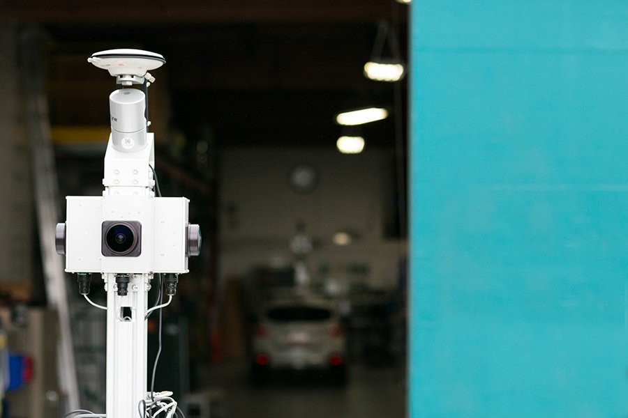
Soon, the data we capture with our cars equipped with best-in-class HD sensor technologies like this…
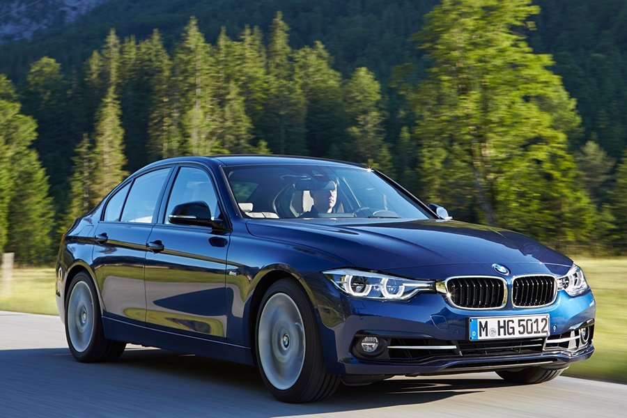
…will be complemented by the data generated by the on-board sensors of regular private cars that look like this.
Millions of them, in fact. Data sourced from the sensors of a vast network of cars will support the creation of HD mapping in the cloud that is constantly evolving to mirror the reality of what is happening on the road.
At the same time, cars will be able to access this mapping to know what lies ahead beyond the reach of their on-board sensors. This means anticipating terrain, lane configurations, hazards or live traffic conditions better than ever before.
Well, this week, HERE is pleased to announce a major step forward in its bid to close the loop: from 2018, we will begin updating HERE HD Live Map, our cloud service for partially, highly and fully automated vehicles, using anonymized data from BMW cars equipped with camera-based Advanced Driver Assist System (ADAS) technology from Mobileye.
You can see the announcement here.
HERE envisages this to be the first of many such announcements. To realize the true promise of autonomous driving, it’s essential that HD mapping can be offered at scale, both in terms of the participating population of vehicles and geographic coverage. To that end, HERE is also in active discussions with several other automakers about the integration of their data in HD Live Map. Stay tuned for more updates!
{{cta('b6a6c6cd-4dca-42b8-b04b-c5c363d791de')}}
Have your say
Sign up for our newsletter
Why sign up:
- Latest offers and discounts
- Tailored content delivered weekly
- Exclusive events
- One click to unsubscribe