Going live: how old maps are being dusted off for a modern world
Believe it or not, Leonardo da Vinci made some of the world's first ever satellite maps. Five hundred years later, HERE is driving the next revolution: the move to living, breathing maps. Here's how.
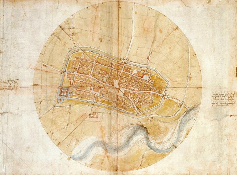
It's a little known fact, but da Vinci didn't just paint the Mona Lisa and design helicopters. His map making work was nothing short of revolutionary. As long ago as 1502, using little more than a compass, he produced a satellite view of the Italian town of Imola, when all around him were drawing maps from the ground level perspective.
But his techniques, though ahead of their time, can no longer support the complex needs of modern travel. Accurate real-time mapping is the next big step forward in cartography. A movement that HERE is proud to be at the forefront of.
With the world celebrating da Vinci's genius on the 500th anniversary of his death, we look at what it took to make his early maps, and what it takes today to bring them into the modern era.
The 16th century: from street view to bird's eye
Da Vinci drew his innovative map of Imola while stationed as a military engineer in the town, tasked with surveying the local landscape. The maps of that era tended to be presented at oblique angles as they were drawn from afar. This left viewers with a perspective that was obscured by uneven topography and offered little information about urban interiors. To remedy this, da Vinci sought to create something like a satellite image.
To do this, he would have relied on the simple tools of the time: a compass to determine orientations, an alidade to capture the angles of streets, and an odometer to record distances. The result is the earliest surviving “ichnographic” map, showing the ground from above – a precursor to the satellite imagery we know today.
Slanted views of rooftops made navigation difficult, prompting da Vinci to look at things from a new angle.
The 21st century: from fixed to flowing
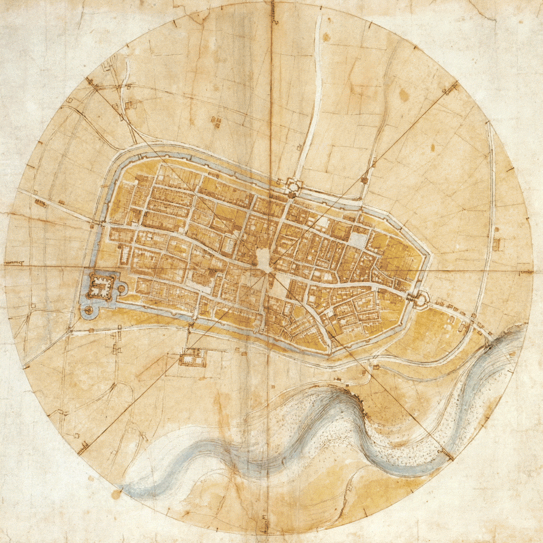
Imola: before and after. As this HERE map shows, da Vinci's version was surprisingly accurate.
Impressive as da Vinci’s work was, his methodology just doesn't give us a realistic view of today's sprawling, ever-changing cities. We now need detailed, accurate and continually updated data, giving live information about variables such as traffic, weather, road closures. We need to move from old static maps to real-time ones.
This doesn't just help the everyday commuter, it also helps:
-
Ambulance drivers take patients to the hospital quicker, and even save lives
-
Police arrive at the scene earlier to prevent crimes
-
City planners learn about the behavior of their cities (and identify areas for improvement)
-
New mobility companies differentiate themselves with better apps for their customers
-
And many more people make their cities safer and more efficient
How is this done? At HERE, we create our real-time HD Live Map using much more than the measurements of one man. We use more than 80,000 sources of geo-referenced data, all gathered in the blink of an eye through our fleet of cars, crowdsourcing, relationships with authorities, sensors in our partners' cars (four out of five of cars in North America and Europe, including Audi, Daimler and Volkswagen) and more. Our real-time data is updated every minute and we provide regular weekly updates to our maps. And because it's an open platform, it's easy for anyone to contribute.
We also create indoor maps, making the move from inside to outside totally seamless, so now every bit of the world is covered.


Our 360-degree view cars are always on the move, sending real-time data to both companies and consumers.
It’s this sort of mapping that provides a complete understanding of a given area right now, from curves and elevation to the locations of lanes and barriers – and paves the way for autonomous driving. With vehicles equipped with a variety of sensors and connected to the cloud, any changes to roads can be detected and distributed to other commuters in near real time, ensuring the information is always accurate.
So Leonardo, we admire what you did, and take inspiration for you, but it's time for the next revolution. And we think you'd be pleased to know that 500 years later, the world is moving on.
Are you a da Vinci fan? Join the 500-year celebrations
You can see the original Imola map for yourself this year. It's on display in Buckingham Palace, London until October, 2019. In September, a curated selection of da Vinci drawings will head to The National Gallery of Art in Washington, D.C. Also in the United States, the Denver Museum of Nature and Science’s “Leonardo da Vinci: 500 Years of Genius” exhibit (March 1 — August 25) will present reproductions of Leonardo’s inventions, historical enactors and the only 360-degree replica of the “Mona Lisa” ever made.
Want to learn more? See how HERE HD Live Map brings you a real-time view of the world around you.

Have your say
Sign up for our newsletter
Why sign up:
- Latest offers and discounts
- Tailored content delivered weekly
- Exclusive events
- One click to unsubscribe